First, thanks to all of you who alerted me to the typo in my last blog post. It's Rockwall County, not "Rockwell."
Second, I've spent some time looking into the size of this, the smallest county in Texas in area. Here's a brief history of the county from the Rockwall County website:
"In 1836, the area was established as part of Nacogdoches County, and when Texas joined the Union in 1845, it was included in Henderson County. Kaufman County was formed in 1847, and the region now known as Rockwall County was placed in Kaufman County. Citizens thought the county seat of Kaufman was too inconvenient, and in 1873, Rockwall County was formed."
The county website says this about the size of Rockwall County:
"Rockwall County is the smallest county in Texas, covering only 147 square miles."
This number agrees with the Texas Historical Marker text found in the 100 block of S. Goliad Street in Rockwall:
"First settled in the 1840s, this region was a part of Kaufman County until 1873, when Rockwall County was created. With an area of 147 square miles, this is the smallest of Texas' 254 counties. The county and city of Rockwall were named for an underground formation of rock discovered in the early 1850s. Crossed by the Missouri, Kansas & Texas Railroad, Rockwall county is an area of fertile farmland. The location here of the aluminum industry and the creation of Lake Ray Hubbard from the East Fork of the Trinity River diversified the local economy in recent years. (1976)"
On the other hand, Wikipedia lists a different area for Rockwall County:
"According to the U.S. Census Bureau, the county has a total area of 149 square miles (390 km2), the smallest county in Texas, of which 129 square miles (330 km2) is land and 20 square miles (52 km2) is (13.39%) water."
Going to the U.S. Census Bureau's Rockwall County "Geography QuickFacts" website, I find that the area of Rockwall County in 2010 is 127.04 square miles. I believe this "area" is in fact, dry land area, not including the portion of the county that is underwater.
I'm going with the official Rockwall County website: 147 square miles.
Which brings up an interesting fact about Rockwall County. Approximately 14% of its original land area was flooded in the late 1960's to create what is now Lake Ray Hubbard. Think about it: for the smallest county in Texas a "loss" of 14% percent of its buildable (and taxable) land (about 20 square miles) is a significant event! On the other hand, the county suddenly had a LOT of new waterfront property.
Here's some background on what Lake Ray Hubbard:
"Ray Hubbard Reservoir is a 22,745-acre impoundment constructed on the East Fork of the Trinity River by the City of Dallas in 1968 to provide water for municipal, industrial, and recreational purposes. Ray Hubbard Reservoir is located one-mile east of Rockwall and lies within Dallas, Collin, Rockwall and Kaufman counties."
Let's compare some maps of Rockwall County to see the impact of Lake Ray Hubbard on the county. For these maps, I have to credit and thank a website I found today while researching this topic: THE PORTAL TO TEXAS HISTORY. The website is http://texashistory.unt.edu/
Here's their description of this remarkable online resource:
"The Portal is a gateway to Texas history materials. You may discover anything from an ancestor's picture to a rare historical map. From prehistory to the present day, you can explore unique collections from Texas libraries, museums, archives, historical societies, genealogical societies, and private family collections. The Portal continues to grow as additional partners contribute digital versions of their collections. We hope you'll return often to discover our latest additions."
Back to Rockwall County. I spent a lot of time online searching for downloadable maps of the county illustrating conditions "before" Lake Ray Hubbard was "impounded" in 1968-70. I had very little success until I stumbled across The Portal to Texas History website. I can already tell that The Portal to Texas History will join my list of "go to" websites as I work on the Texas Courthouse website.
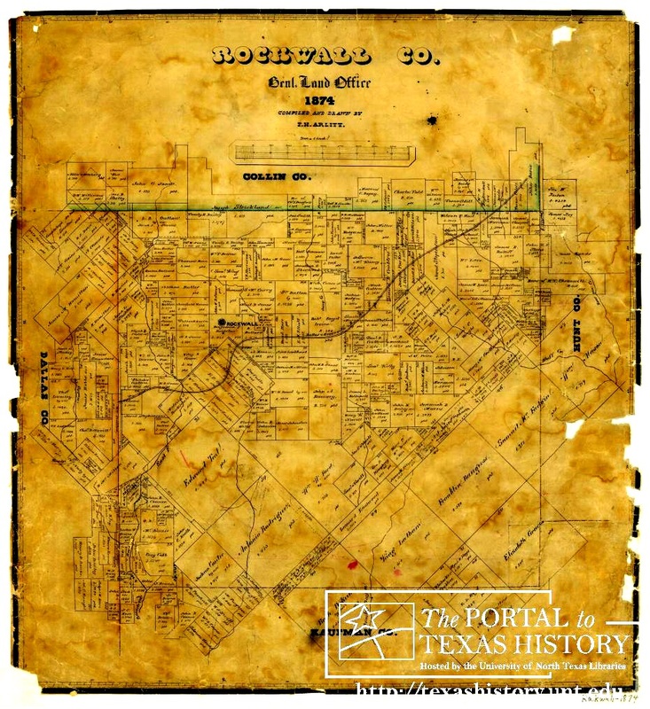
Let's start with a Land Map of Rockwall County from 1874, a year after the county was formed. I've overexposed it so you can see the land plats. The East Fork of the Trinity River runs north-south just inside the western boundary of Rockwall County, on the left side of the map. The East Fork of the Trinity River would, in 1968, become Lake Ray Hubbard. But, in 1874 it was just a river. (The dark line running west to northeast across the county is a railroad.)
Second, I've spent some time looking into the size of this, the smallest county in Texas in area. Here's a brief history of the county from the Rockwall County website:
"In 1836, the area was established as part of Nacogdoches County, and when Texas joined the Union in 1845, it was included in Henderson County. Kaufman County was formed in 1847, and the region now known as Rockwall County was placed in Kaufman County. Citizens thought the county seat of Kaufman was too inconvenient, and in 1873, Rockwall County was formed."
The county website says this about the size of Rockwall County:
"Rockwall County is the smallest county in Texas, covering only 147 square miles."
This number agrees with the Texas Historical Marker text found in the 100 block of S. Goliad Street in Rockwall:
"First settled in the 1840s, this region was a part of Kaufman County until 1873, when Rockwall County was created. With an area of 147 square miles, this is the smallest of Texas' 254 counties. The county and city of Rockwall were named for an underground formation of rock discovered in the early 1850s. Crossed by the Missouri, Kansas & Texas Railroad, Rockwall county is an area of fertile farmland. The location here of the aluminum industry and the creation of Lake Ray Hubbard from the East Fork of the Trinity River diversified the local economy in recent years. (1976)"
On the other hand, Wikipedia lists a different area for Rockwall County:
"According to the U.S. Census Bureau, the county has a total area of 149 square miles (390 km2), the smallest county in Texas, of which 129 square miles (330 km2) is land and 20 square miles (52 km2) is (13.39%) water."
Going to the U.S. Census Bureau's Rockwall County "Geography QuickFacts" website, I find that the area of Rockwall County in 2010 is 127.04 square miles. I believe this "area" is in fact, dry land area, not including the portion of the county that is underwater.
I'm going with the official Rockwall County website: 147 square miles.
Which brings up an interesting fact about Rockwall County. Approximately 14% of its original land area was flooded in the late 1960's to create what is now Lake Ray Hubbard. Think about it: for the smallest county in Texas a "loss" of 14% percent of its buildable (and taxable) land (about 20 square miles) is a significant event! On the other hand, the county suddenly had a LOT of new waterfront property.
Here's some background on what Lake Ray Hubbard:
"Ray Hubbard Reservoir is a 22,745-acre impoundment constructed on the East Fork of the Trinity River by the City of Dallas in 1968 to provide water for municipal, industrial, and recreational purposes. Ray Hubbard Reservoir is located one-mile east of Rockwall and lies within Dallas, Collin, Rockwall and Kaufman counties."
Let's compare some maps of Rockwall County to see the impact of Lake Ray Hubbard on the county. For these maps, I have to credit and thank a website I found today while researching this topic: THE PORTAL TO TEXAS HISTORY. The website is http://texashistory.unt.edu/
Here's their description of this remarkable online resource:
"The Portal is a gateway to Texas history materials. You may discover anything from an ancestor's picture to a rare historical map. From prehistory to the present day, you can explore unique collections from Texas libraries, museums, archives, historical societies, genealogical societies, and private family collections. The Portal continues to grow as additional partners contribute digital versions of their collections. We hope you'll return often to discover our latest additions."
Back to Rockwall County. I spent a lot of time online searching for downloadable maps of the county illustrating conditions "before" Lake Ray Hubbard was "impounded" in 1968-70. I had very little success until I stumbled across The Portal to Texas History website. I can already tell that The Portal to Texas History will join my list of "go to" websites as I work on the Texas Courthouse website.
Let's start with a Land Map of Rockwall County from 1874, a year after the county was formed. I've overexposed it so you can see the land plats. The East Fork of the Trinity River runs north-south just inside the western boundary of Rockwall County, on the left side of the map. The East Fork of the Trinity River would, in 1968, become Lake Ray Hubbard. But, in 1874 it was just a river. (The dark line running west to northeast across the county is a railroad.)
Clearly, at the time, a lot of people owned land in what is now a lake. Here's another "before" view. A 1923 county soils map that also illustrates the pre-lake county lands.
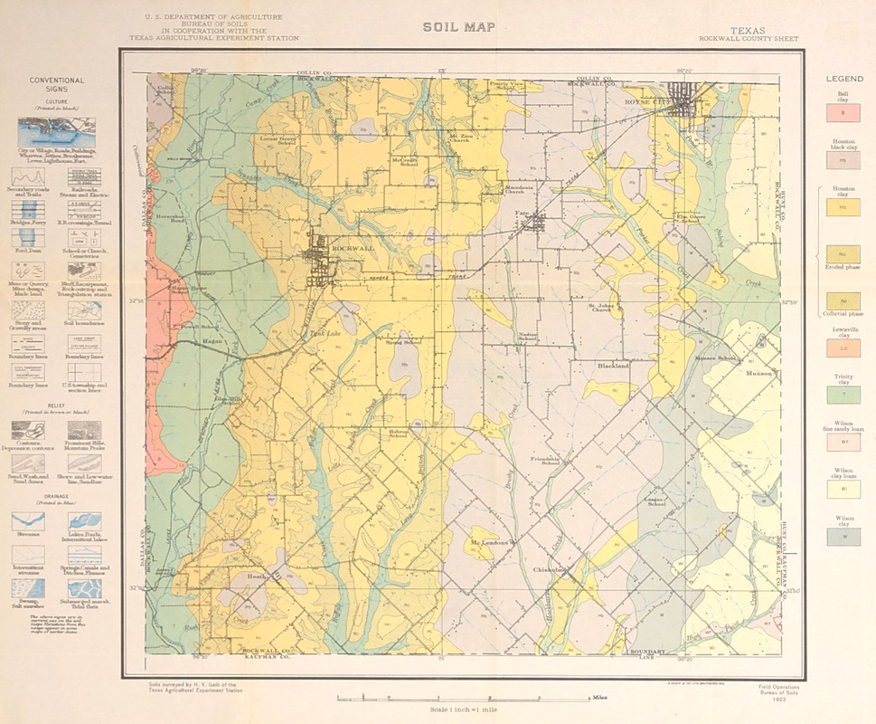
The soil "types" are color-coded and the green color on the west side of the county indicates "Trinity Clay" soils. Below, are two road maps of Rockwall County. The one on the left is dated 1961. The one on the right is from 1972.
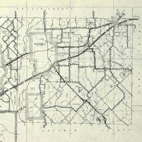 Rockwall County TX roads 1961 | 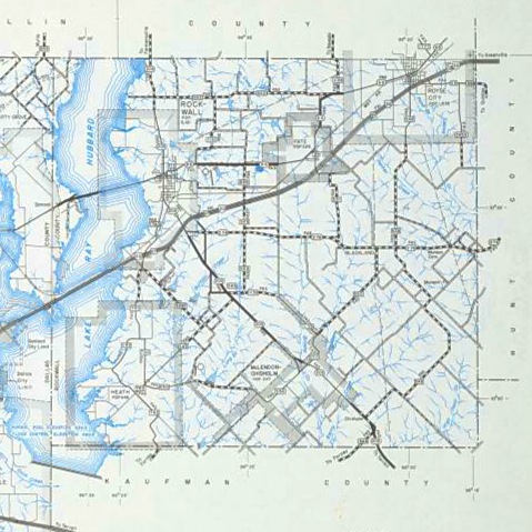 Rockwall County TX roads 1972 |
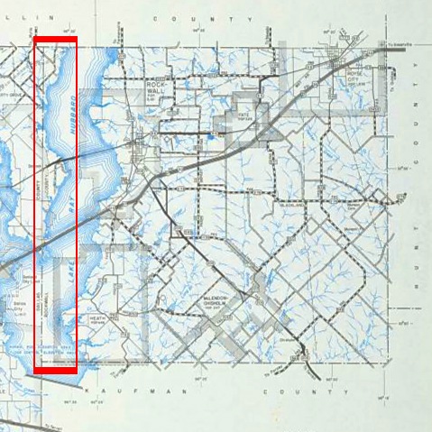
The impact of Lake Ray Hubbard on the geography of the county is very apparent. Like I said, a lot of new waterfront property was created. Here's a larger image of the 1972 map. Notice that portions of Rockwall County on the west side of the lake (in the red rectangle) were now physically separated from the rest of the county. If you're in the part of Rockwall County west of the lake and north of Interstate 30, look for Dalrock Road. It's median is the dividing line between Rockwall and Dallas Counties.
From what I can tell, Rockwall County is substantially better off as a result of flooding 20 square miles of it's 147 square miles. All joking aside, the land lost to Lake Ray Hubbard isn't missed. The new recreational uses of the lake, not to mention the source of water for the surrounding area, is a positive improvement, and the waterfront property in Rockwall County is proving very valuable as this county has become a highly desirable address in the Dallas area.
(Next Saturday, July 28, I'll be visiting Loving County, the other "smallest" county in Texas, with a population of 82.)
(Next Saturday, July 28, I'll be visiting Loving County, the other "smallest" county in Texas, with a population of 82.)
 RSS Feed